Blog
All Blog Posts | Next Post | Previous Post

 Polygon Holes, Marker Clusters and Truck Routing in TMS FNC Maps v3.5 for Delphi
Tuesday, December 6, 2022
![]()
One more update before the end of the year for our all-in-one mapping solution TMS FNC Maps.
Includes the following new features:
- Polygon Holes
- Marker Clusters
- Truck Routing
Polygon Holes (or Complex Polygons)
Cut out holes in polygons with the new complex polygon support.

To add holes to an existing polygon, simply use the AddHole call with an array of coordinates.
var
  ArrPoly, ArrHole: TTMSFNCMapsCoordinateRecArray;
  Polygon: TTMSFNCGoogleMapsPolygon;
begin
  Setlength(ArrPoly, 3);
  ArrPoly[0].Longitude := -80.19;
  ArrPoly[0].Latitude := 25.774;
  ArrPoly[1].Longitude := -66.118;
  ArrPoly[1].Latitude := 18.466;
  ArrPoly[2].Longitude := -64.757;
  ArrPoly[2].Latitude := 32.321;

  Setlength(arr2, 3);
  ArrHole[0].Longitude := -66.668;
  ArrHole[0].Latitude := 27.339;
  ArrHole[1].Longitude := -67.514;
  ArrHole[1].Latitude := 29.57;
  ArrHole[2].Longitude := -70.579;
  ArrHole[2].Latitude := 28.745;

  Polygon := TMSFNCGoogleMaps1.AddPolygon(ArrPoly);
  Polygon.FillColor := gcBlue;
  Polygon.StrokeWidth := 0;
  Polygon.AddHole(ArrHole);

  TMSFNCGoogleMaps1.ZoomToBounds(ArrPoly);
end;
Polygon holes are supported for the following mapping services:
Google Maps, OpenLayers, Bing, Here, MapKit
![]()
![]()
![]()
![]()
![]()
A sample can be found here:
https://github.com/holgerflick/examples/tree/06_maps_polygon_hole
Marker Clusters
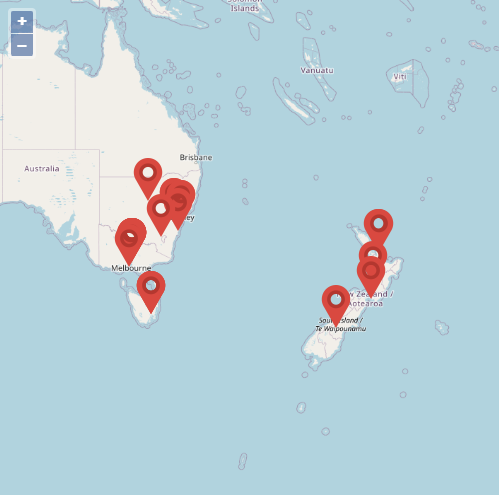
Clusters allow grouping of multiple markers into one or more clusters. This was previously only supported for Google Maps, but now support for OpenLayers has been added as well.


To display clustered Markers, simply add a Cluster and then assign the Cluster to each Marker that should be included.
var
  mo: TTMSFNCOpenLayersMarker;
  I: Integer;
  locations: array of TTMSFNCMapsCoordinateRec;
begin
   locations := [
   CreateCoordinate(-31.563910, 147.154312),
   CreateCoordinate(-33.718234, 150.363181),
   CreateCoordinate(-33.727111, 150.371124),
   CreateCoordinate(-33.848588, 151.209834),
   CreateCoordinate(-33.851702, 151.216968),
   CreateCoordinate(-34.671264, 150.863657),
   CreateCoordinate(-35.304724, 148.662905),
   CreateCoordinate(-36.817685, 175.699196),
   CreateCoordinate(-36.828611, 175.790222),
   CreateCoordinate(-37.750000, 145.116667),
   CreateCoordinate(-37.759859, 145.128708),
   CreateCoordinate(-37.765015, 145.133858),
   CreateCoordinate(-37.770104, 145.143299),
   CreateCoordinate(-37.773700, 145.145187),
   CreateCoordinate(-37.774785, 145.137978),
   CreateCoordinate(-37.819616, 144.968119),
   CreateCoordinate(-38.330766, 144.695692),
   CreateCoordinate(-39.927193, 175.053218),
   CreateCoordinate(-41.330162, 174.865694),
   CreateCoordinate(-42.734358, 147.439506),
   CreateCoordinate(-42.734358, 147.501315),
   CreateCoordinate(-42.735258, 147.438000),
   CreateCoordinate(-43.999792, 170.463352)];

   TMSFNCOpenLayers1.BeginUpdate;
   TMSFNCOpenLayers1.Clusters.Add;

   for I := 0 to Length(locations) - 1 do
   begin
     mo := TTMSFNCOpenLayersMarker(TMSFNCOpenLayers1.AddMarker(locations[I]));
     mo.Cluster := TMSFNCOpenLayers1.Clusters[0];
   end;

  TMSFNCOpenLayers1.ZoomToBounds(TMSFNCOpenLayers1.Markers.ToCoordinateArray);
  TMSFNCOpenLayers1.EndUpdate;
end;
Marker Clusters are supported for the following mapping services:
Google Maps, OpenLayers
![]()
![]()
Truck Routing
A new feature only for Here. Add extra configurable options to your truck routing to get directions specifically aimed at trucks.
You can, for example, add truck dimensions and weight to retrieve a route that is optimized based on the provided values.
Truck routing options are only supported for Here Directions.![]()
Note: The routing information can be displayed on all supported mapping services.
A sample can be found here:
https://github.com/holgerflick/examples/tree/05_maps_here_truck
Available Now
The TMS FNC Maps update is available now for Delphi & Visual Studio Code (with TMS WEB Core). You can download the latest version and start using the new features right away!
Bart Holvoet

This blog post has not received any comments yet.
All Blog Posts | Next Post | Previous Post